Research projects
HOMeBIM liveAPP
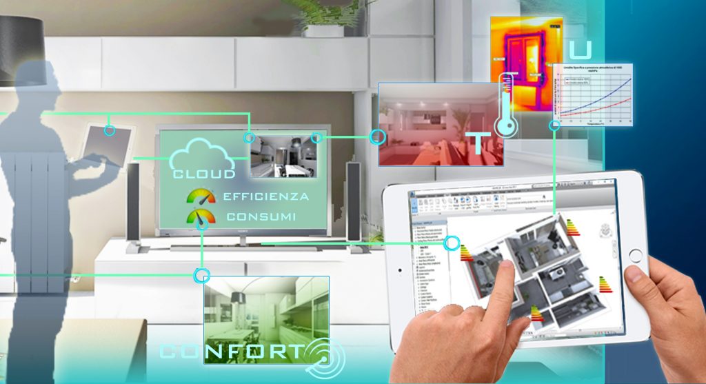
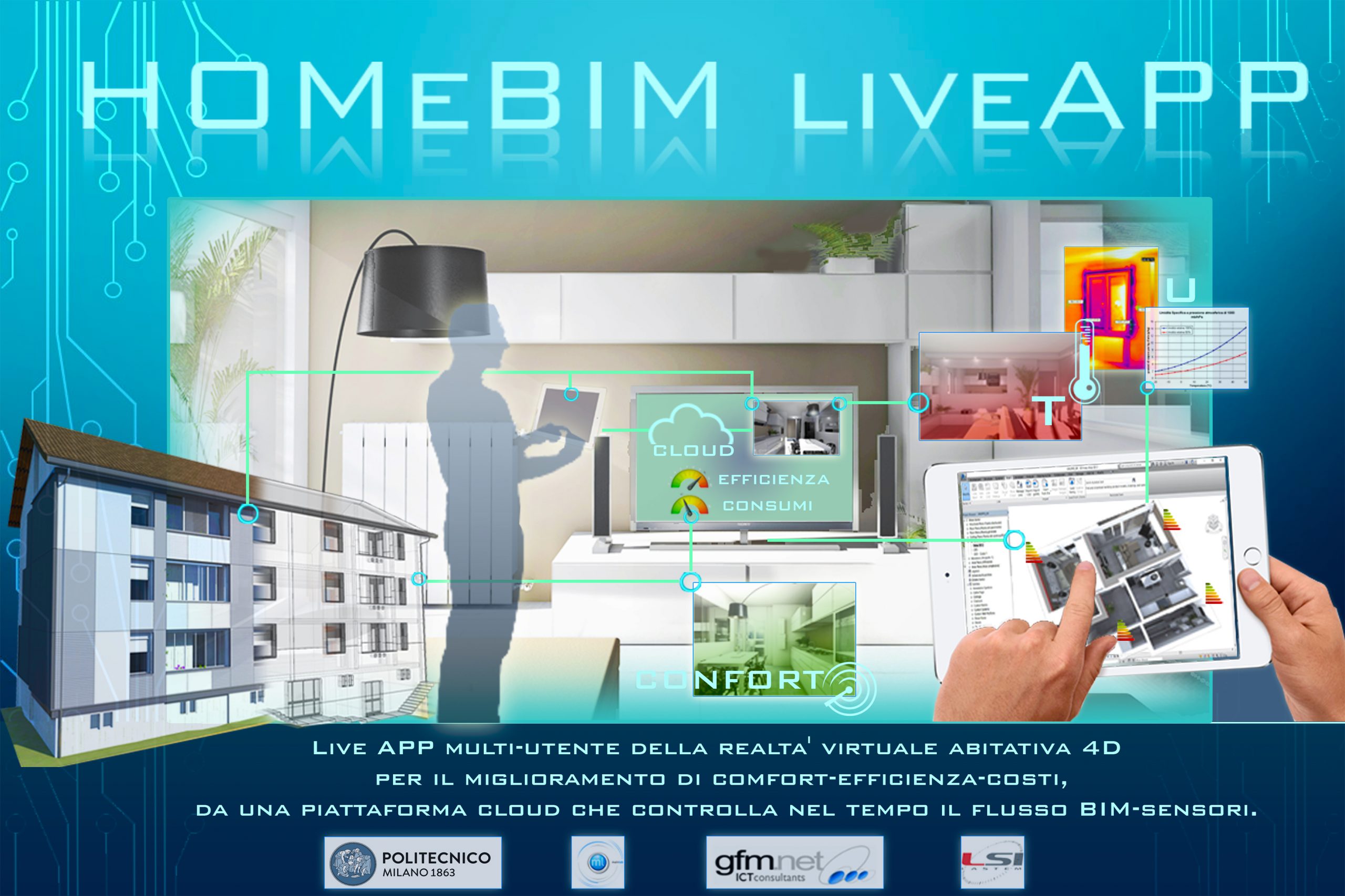
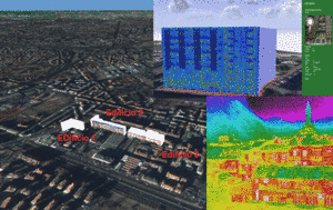
Sviluppo di una Live APP multi-utente della realtà virtuale abitativa 4D per il miglioramento di comfort-efficienza-costi, da una piattaforma cloud che controlla nel tempo il flusso BIMsensori.
ID progetto 379270 ” (D.d.u.o. 24 novembre 2017 – n. 14782)
Bando per la presentazione di Progetti di sviluppo sperimentale e innovazione (S&I) a favore della filiera dello “Smart Living”, in attuazione della legge regionale 26/2015 “Manifattura diffusa, creativa e tecnologica 4.0” per l’integrazione tra produzione, servizi e tecnologia nella filiera costruzioni legno-arredo- casa, in attuazione della strategia ‘Lombardia 5.0’: politiche per il consolidamento e la valorizzazione delle filiere eccellenti lombarde.
Progetto realizzato nell’ambito del bando Smart Living: Integrazione tra produzione servizi e tecnologia nella filiera costruzioni-legno-arredo-casa finanziato da Regione Lombardia – Progetto HOM & BIM live APP – ID: 379270

Energic-OD
(Competitiveness and Innovation Framework Programme (CIP) – 2014-16) European NEtwork for Redistributing Geospatial Information to user Communities – Open Data
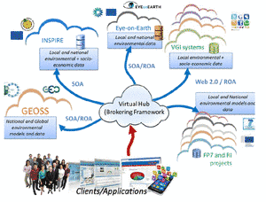
The project will deploy a set of Virtual Hubs (VH) by integrating an existing broker framework with other selected technologies to provide users with a single point of access to geospatial datasets provided by new or existing platforms and infrastructures, including INSPIRE-compliant systems and GMES/Copernicus services. In this approach, specific components (the brokers) perform all interoperability actions required to interconnect heterogeneous systems
New Paradigms/
New Tools for Heritage Conservation in Canada
Funded through the Social Sciences and Humanities Research Council (SSHRC) of Canada, Partnership Grants (2016-22) — Partnered Research Training Initiative Program, Lead Applicant (Carleton University)
The project will offer a novel research and training program that questions theoretical, practical and ethical imperatives surrounding the use of new and emerging digital technologies for the conservation and rehabilitation of Canada’s built heritage. Graduate students, PhD candidates, and post-doctoral fellows will have the opportunity to undertake interdisciplinary research and training with some of the world’s leading academics and professionals working in the application of digital technologies for architectural heritage.
BACA
Capacity building proposal for documentation of built heritage for Bahrain Authority for Culture and AntiquitiesThe project will provide local staff the use of specific recording techniques to document and therefore preserve built heritage sites with appropriate accuracy and in a relatively short period. A pilot project will be conducted in collaboration with BACA to validate the capacity of the team to accurately record and produce measured records for the conservation of built heritage in Bahrain.
The project is conducted by a multidisciplinary team of experts from Carleton Immersive Media Studio (CIMS, Carleton University, Ottawa, Canada), and Gicarus Lab (Politecnico di Milano)
GEOSPATIAL Community
Programma POR FESR Fondo europeo di sviluppo regionale – Asse 1 Innovazione ed Economia della conoscenza, 2015-16. Attività di ricerca: sviluppo di una rete di soggetti pubblici e privati (PPP), centri di ricerca e imprese, avente come focus la centralità oggi trasversale di dati e servizi Geospaziali downstream ad ampio spettro, allargata alla partecipazione di attori afferenti a vari settori come salute, energia, agricoltura e sicurezza del territorio.
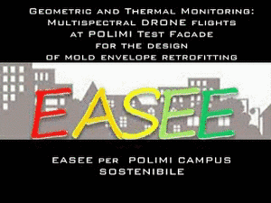
Easee
| |
EASEE per POLIMI Campus Sostenibile (E. Pizzi, R. Brumana): Geometric and thermal monitoring from UAV: multispectral micro drone flights for building and facade monitoring for mold envelope retrofitting solutions | |
Sinopiae
(ERDF-FESR Funds) Multi-source prototype system for integration of multispectral observation (satellite/aerial/uav/ground), for the multi-scale monitoring of environmental indicators (atmospheric constituents and energy dispersion
CPRE
(INTERREG, 2013-14)
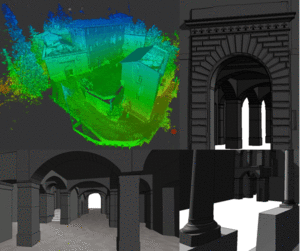
La Conservazione Programmata nello spazio comune REtico – Castel Masegra: creation of BIM of the whole site starting from laser scanning and photogrammetric data
Ecomuseo Tremezzina
Multimedia system for the presentation and participated recognizing of the environmental values of the landscape of the Lake of Como
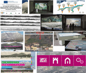
Sistema multimediale per la presentazione e per il riconoscimento partecipato dei valori ambientali del paesaggio lariano), Asse 4 Tutela e Valorizzazione del patrimonio naturale e culturale, realizzazione e promozione di itinerari turistici per la fruizione sostenibile delle risorse culturali e ambientali. Province of Como scientific responsible, with the support of Polimi: Prof. S. Della Torre, R. Brumana for the realization of the Tremezzina multimedia museum